Space for farm data to grow
Once, rooftop farms were a novelty. Now they're a secret weapon.

I’m often thinking about the visual power of earth observation data, zooming out to see the big picture within a single frame, but the opposite is also true. Spatial and temporal resolutions are getting higher and higher - allowing us to see incredible detail (down to 15cm commercially) of any area in the world, multiple times a day. That has invariably caused some concern surrounding privacy issues, which are valid, but a topic better left for a whole newsletter unto itself.
—
We can look at past trends, see what’s happening currently, and start to predict what lies ahead.
For the remote sensing community, this has unlocked deeper insights into highly complex systems like: agriculture, oceanography, urban development, etc. New patterns and relationships emerge, allowing for a more holistic understanding of interdependencies between seemingly distinct systems.
Temporal resolution refers to the cadence of capturing data or, how many times the satellite revisits the same location within a given period of time. With 6-12 hr cadence now looking to become commonplace, the value of historical data overlapping with near real-time information offers a mouth watering proposition.
For agriculture, these insights allow producers to:
plan more efficiently,
monitor crops in real time, and
know when/how to allocate resources with confidence.
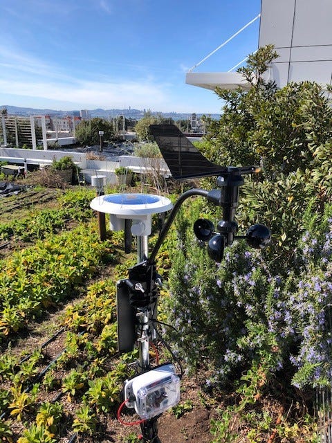
Assuming these observations would benefit any producer, in any location, why not give an urban rooftop farmer access to the same information? To test this theory, DirtSat has begun placing Internet of Things (IoT) sensors on urban rooftop farms.
This represents a first major milestone for DirtSat — providing greater insights into the growing cycle and arming urban producers with a diverse range of tools.

—
Proof of Concept (PoC) 🌱
The first DirtSat PoC officially kicked off in Northern California this February. Two IoT sensors are deployed on separate rooftop farms in the Bay Area (Berkeley and San Francisco, with Oakland up next).
The goal is to test the ability of the sensors to capture crop health data and deliver analytics in an urban environment.
These sensors are typically deployed on rural farms, in wide open fields. Introducing distinctly urban conditions like shadows and reflections (from adjacent buildings and materials) may affect the sensor’s ability to collect or interpret the data.
The resulting metrics will inform the next stage of technology development and help flesh out the DirtSat platform.
By partnering with key urban agriculture proponents, an important cross-section of the local communities are enlisted as well -
Commercial farmers, private producers, and non-profit neighborhood development organizations.
—
Green space for healthy living
Where many intelligent minds have looked to bring food production back into urban centers through indoor vertical farming operations, we see rooftops as a viable extension of those efforts.
We’re using precision AgTech to help urban producers augment their operations and increase efficiencies. But we also see power in numbers, not only to increase food production, but to provide greater potential to:
affect urban heat islands,
capture storm water runoff, and
reintroduce wildlife habitat.
Adding green roofs can alter the surrounding ambient temperatures in cities up to 5°F. Imagine what a city-wide network of 100 or 1000 rooftops would do to increase livability in dense urban areas?
Satellites have an easier time seeing what’s on top of buildings than what’s between them, and typically, the fight for development happens over vacant lots and not rooftops. Though I suppose air rights for tomatoes could become ‘a thing’.
—
What’s next
Looking at three technology verticals under development at DirtSat — Indexing, Connecting, Monitoring — the first proof of concept focuses on the IoT/Geospatial data vertical. We’re evaluating the promise of IoT as the technological engine to drive the DirtSat network.
As monitoring of these first locations continues, our sights are also set on the next deployment phase - scheduled for New York City in early May. We’ll be throwing the ‘kitchen sink’ of possible interferences at three sites across Brooklyn and Queens.
Mirroring preparation for the growing season — pruning, amending soil and developing a maintenance strategy — I’ve been busy preparing ‘the ground’ for the next phase.
Drip-mapping rooftop locations, tasking satellite imagery, and tilling inputs/outputs for neural networks.
P.S. Your feedback counts and is very appreciated. And, if you’re finding this newsletter valuable, consider sharing.
Bonus process content:
^ First iteration of a ‘homemade’ portable footing.


Excellent!
SO rad. Great work and congrats!